Abalone Cove Foundation · Library of Evidence

The Documentary Record

A formal library of primary and secondary sources bearing on 0 Clipper Road and the coastal south face of the Palos Verdes Peninsula. Entries are numbered for citation, organized by source type, and marked by access level: A indicates a document held locally (transcription, PDF, or image); B indicates a document cited but not yet obtained. Citations follow Chicago style for historical, geological, and regulatory sources and Bluebook style for case law and statutes. Each entry links to its transcription, original file, map layer, or external source as applicable.

§ I

Palos Verdes Corporation Declarations (1923–1952)

Recorded private instruments establishing the peninsula's original covenant scheme and its implementing tracts.

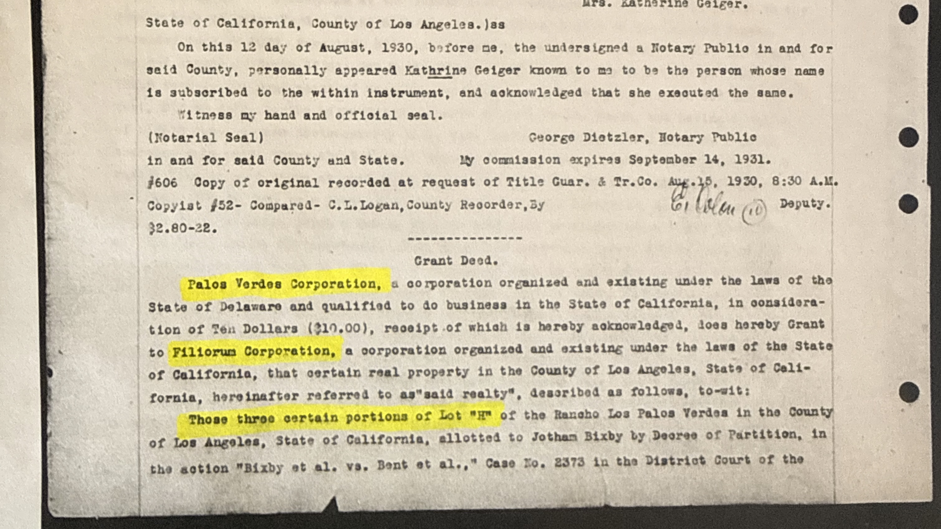
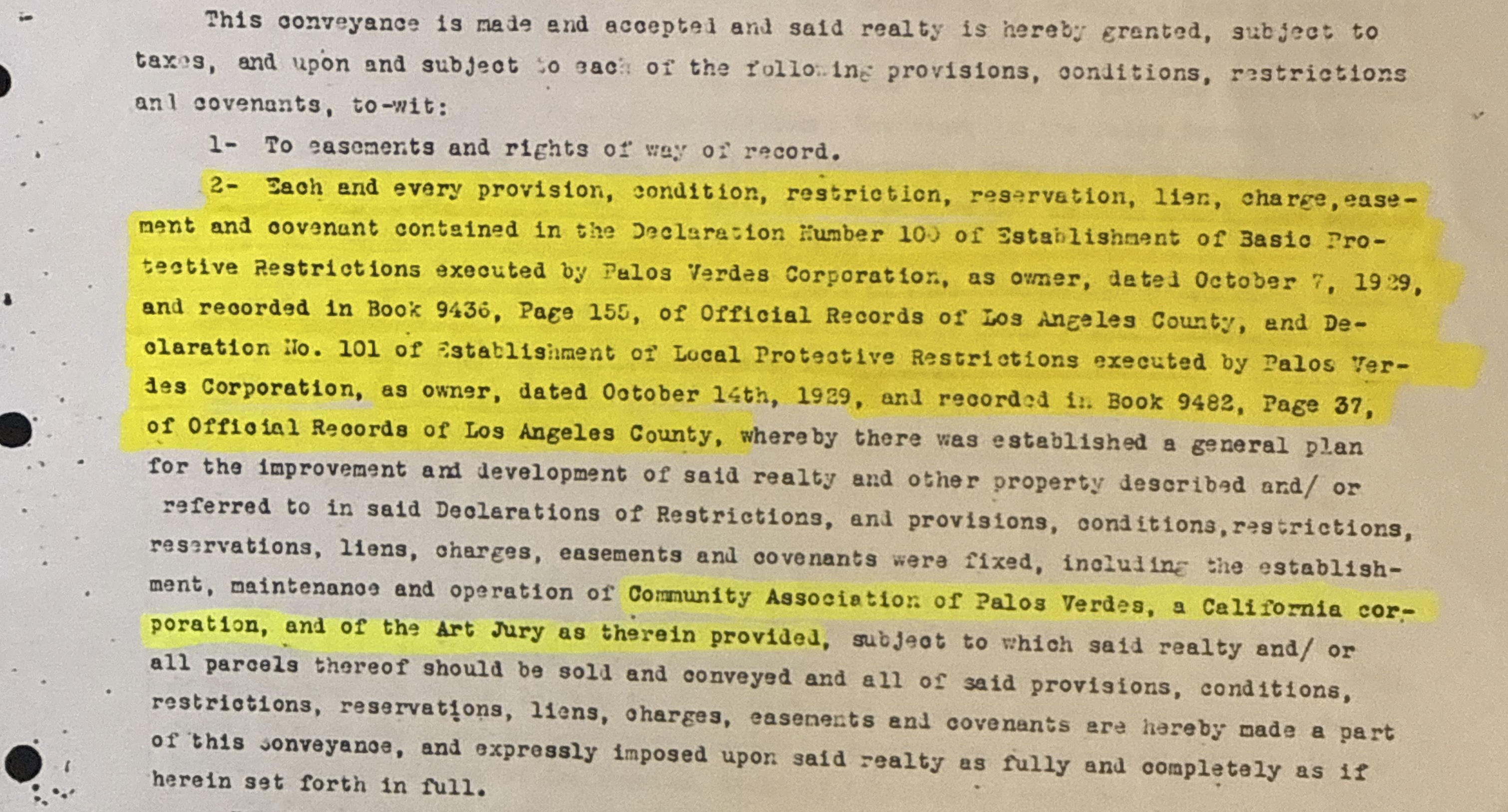
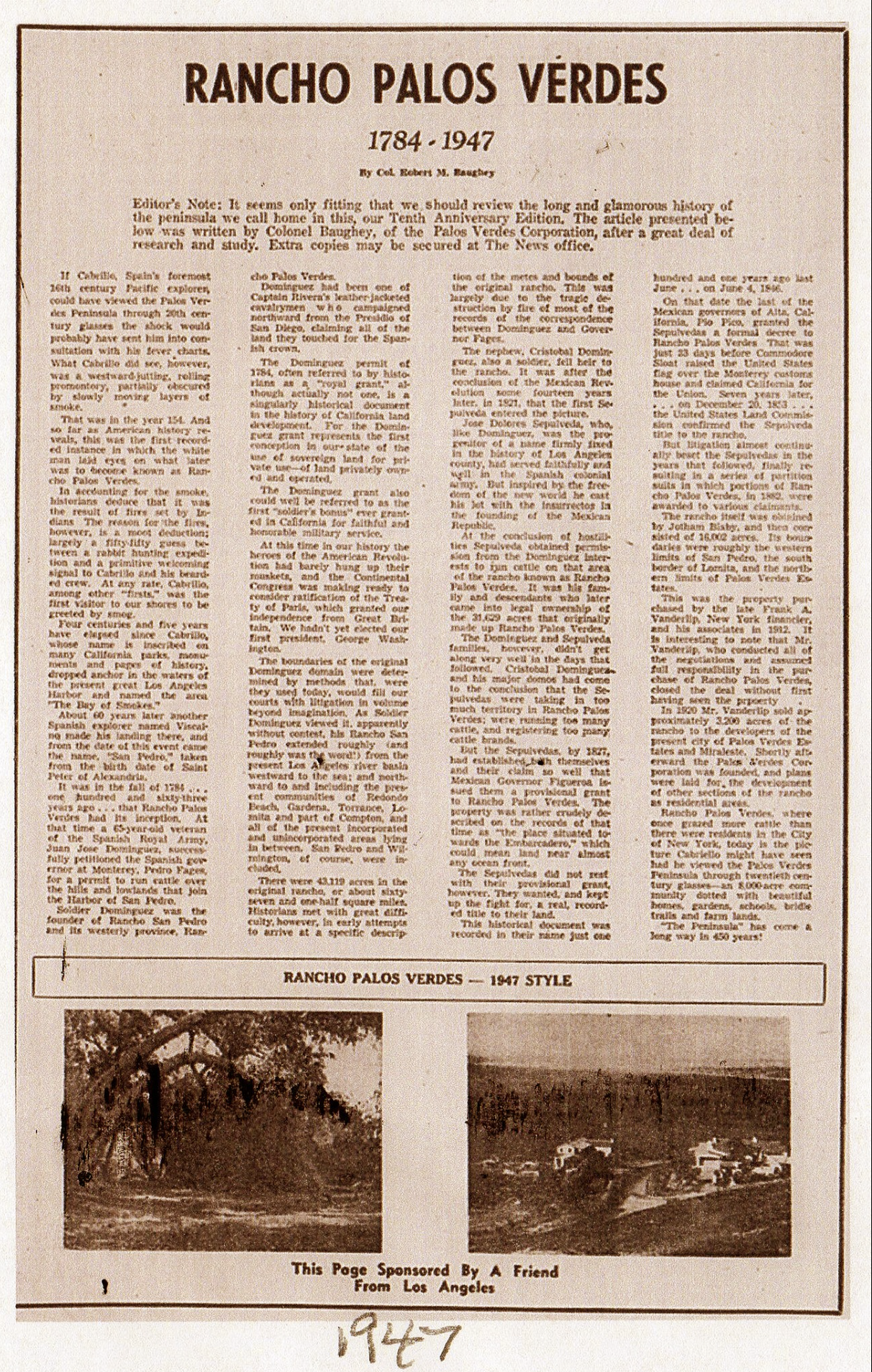
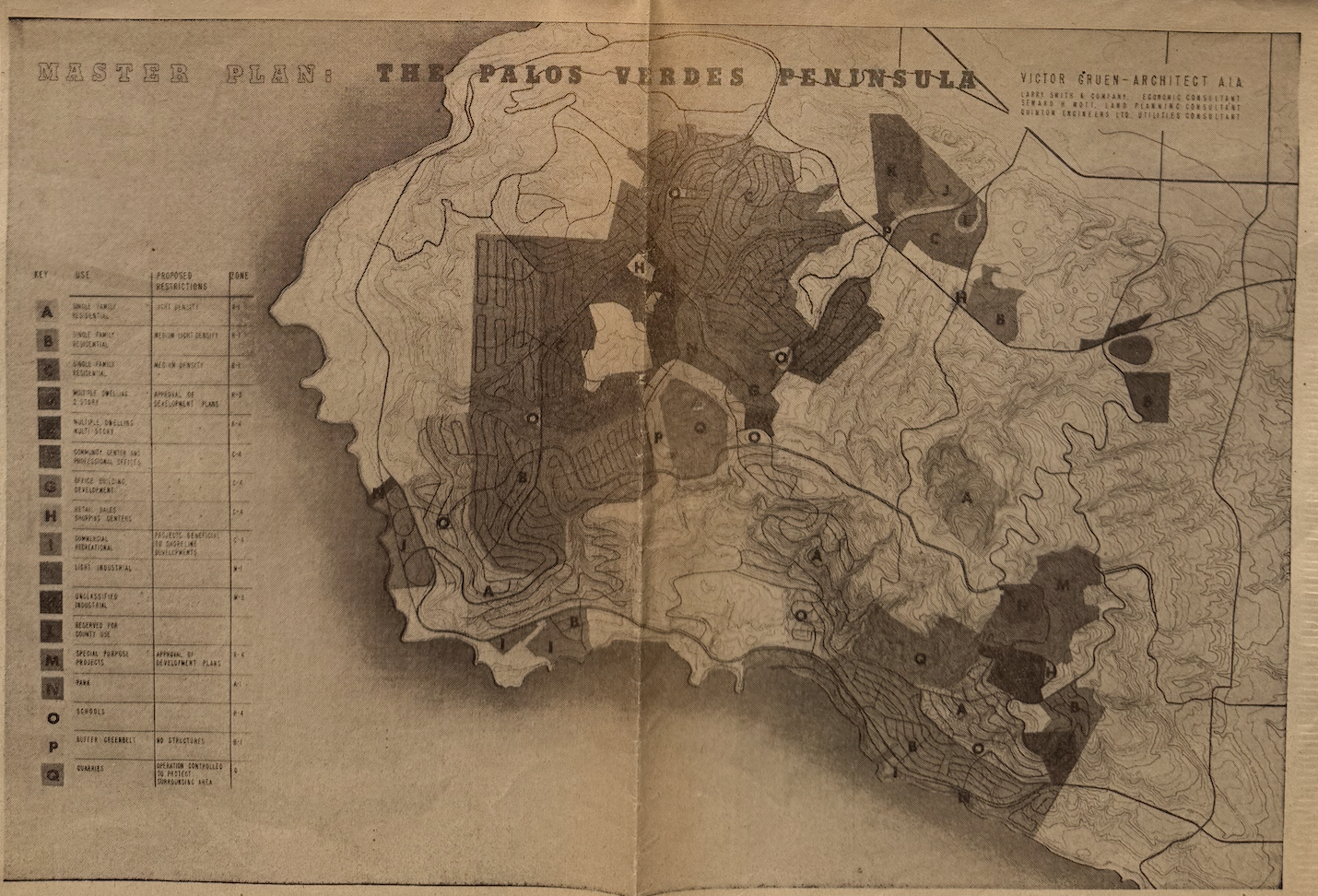
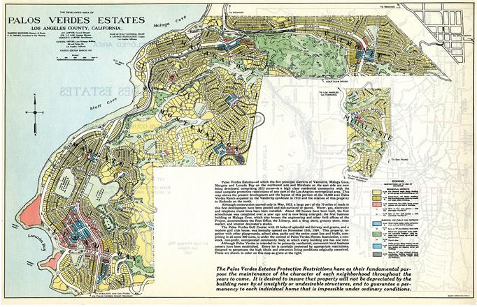
Declaration No. 1 — Basic Protective Restrictions, Palos Verdes Estates B
Palos Verdes Corp., Declaration of Establishment of Basic Protective Restrictions, Conditions, Covenants, Reservations, Liens and Charges, filed Jan. 25, 1923, L.A. County Recorder.
Original governing declaration for Palos Verdes Estates and Miraleste. Establishes the Palos Verdes Homes Association and the Art Jury. Referenced throughout the declaration scheme as the PVE framework distinct from Declaration 100.
Declaration No. 100 — Basic Protective Restrictions A
Palos Verdes Corp. (Del.), Declaration of Establishment of Basic Protective Restrictions, Conditions, Covenants, Reservations, Liens and Charges, dated Oct. 7, 1929, recorded Oct. 10, 1929, Book 9436, pp. 155–178, Official Records, L.A. County Recorder. Signed Jay Lawyer, VP; Donald K. Lawyer, Asst. Sec.; notarized Nellie Grace Frantz.
Constitutional framework for all of Lot H outside PVE. Articles I–V establish general basic restrictions, the Community Association of Palos Verdes, the Art Jury, use-district zoning (Classes A–K), height districts, architecture types I–IV, and a duration running to January 1, 1965 with auto-renewing 20-year periods thereafter. Page 155 (metes-and-bounds description) is illegible on the county microfilm.
Full verbatim Partial microfilm transcript
Declaration No. 101 — Local Protective Restrictions A
Palos Verdes Corp. (Del.), Declaration of Establishment of Local Protective Restrictions, Conditions, Covenants, Reservations, Liens and Charges, dated Oct. 14, 1929, recorded Oct. 19, 1929, Book 9482, p. 37, Official Records, L.A. County Recorder.
Implementing instrument under Declaration 100 assigning seven specific Portuguese Bend parcels to Class A residential, 2½-story height, Type I (Mediterranean, burned clay tile) architecture. $20,000 minimum construction cost; 25-foot setbacks. This is the source of the Portuguese Bend Red Tile District.
Verbatim transcription Seven parcels legal descriptions Map layer
Palos Verdes Corp. → Filiorum Corp. Grant Deed A
Grant Deed, Palos Verdes Corp. to Filiorum Corp., dated Aug. 15, 1930, recorded Aug. 18, 1930, Book 10226, pp. 170–174, Official Records, L.A. County Recorder. Consideration: $10.
Conveys three portions of Lot H from PV Corp to the Filiorum Corporation and expressly incorporates each and every provision of Declarations 100 and 101. The operative link between the declaration scheme and the parcels later conveyed back to the City in the 2014 redevelopment dissolution.
Verbatim transcription Original (PDF) Deed image — grant Deed image — restrictions
Declaration No. 150 — Rolling Hills General Plan B
Palos Verdes Corp., Declaration establishing General Plan of Restrictions for Rolling Hills, dated May 14, 1936, recorded L.A. County Recorder.
Master general plan for the original Rolling Hills tract. Contains the Tree-Cutting Covenant (Art. I, § 11) and the Community Association framework. Recited in Russell v. Palos Verdes Properties (1963) and Colyear v. Rolling Hills C.A. (2024) as the direct analog of Declaration 100 for Rolling Hills. Covers only a narrow strip; subsequent tracts annexed under 150-A through 150-V and 150-W.
Declaration No. 150-M — Rolling Hills Annexation B
Palos Verdes Corp., annexation declaration, recorded May 29, 1944, L.A. County Recorder.
Annexation instrument governing the property at issue in Colyear. Does not contain the Tree CC. Held insufficient to incorporate Declaration 150 by reference, establishing that PVC's intended uniform general plan is not enforceable where later implementing declarations were intentionally simplified.
Declaration No. 160 — Flying Triangle B
Palos Verdes Corp., annexation declaration, recorded 1939, L.A. County Recorder.
The annexation instrument from which, per Kelvin Vanderlip's 1947 letter, PVC's attorneys began to remove provisions "for the purpose of simplification." Documented in the Swaffield Study (1947) and confirmed by the California Court of Appeal in Colyear (2024).
Declaration of Easements — Tract 14195 A
PV Corp, Declaration of Easements, 1948, Book 28991, L.A. County Recorder.
Verbatim
Declaration of Easements — Tract 14500 A
PV Corp, Declaration of Easements, 1948, Book 28991, L.A. County Recorder.
Verbatim
Lot “H” Declaration of Protective Restrictions A
Palos Verdes Corp. (Del.), Declaration of Protective Restrictions, dated Jan. 25, 1950, recorded Book 32160, pp. 26–36, Official Records, L.A. County Recorder.
Cleanup-sweep declaration covering all Lot H property still held by PV Corp as of January 25, 1950, with eleven named tracts excepted (Rolling Hills at MB 201/29–35 and Tract 14649 among them). Establishes single-family restrictions on remaining PV Corp land and auto-renews.
Verbatim
PV Corp Grant Deed — Lot 1 A
Palos Verdes Corp., Grant Deed, 1952.
Verbatim Original (PDF)
Nelson → Taylor Grant Deed A
Grant Deed, 1952, Book 39174, Official Records, L.A. County Recorder.
Original (PDF)
§ II

WPBCA Governance (1949–2009)

Founding and governing instruments of the West Portuguese Bend Community Association, the HOA that holds CC&R enforcement authority over 71% of Subregion 4.

WPBCA Declaration No. One A
West Portuguese Bend Community Ass'n, Declaration No. One, dated Apr. 29, 1949, recorded Book 29980, p. 159, Official Records, L.A. County Recorder.
Founding declaration of WPBCA. Subdivides 32 acres into 81 single-family lots, establishes the Architectural Committee, imposes CC&Rs on Tract 14649.
Verbatim Original (PDF) OCR PDF
Declaration of Easements (Tract 14649) A
Declaration of Easements, dated May 5, 1949, recorded Book 30051, pp. 385–393, Official Records, L.A. County Recorder.
Records the bridle trail (ocean-access path), drainage, and utility easements for Tract 14649. The foundation of the HOA's beach path standing.
Verbatim Original (PDF)
Modification of Protective Restrictions A
West Portuguese Bend Community Ass'n, Modification of Protective Restrictions, 1949.
Verbatim
1949–1950 Amendments A
WPBCA, Declaration Amendments, 1949–1950.
Original (PDF) OCR PDF
Declaration One-A A
West Portuguese Bend Community Ass'n, Declaration One-A, 1950.
Verbatim
Restated Declaration of Covenants, Conditions & Restrictions A
West Portuguese Bend Community Ass'n, Restated Declaration, recorded 2009, L.A. County Recorder.
Current operative CC&Rs of WPBCA. Consolidates and restates the 1949 declaration, 1949 easements, and subsequent amendments. The last time the HOA achieved a quorum.
Full text Original (PDF)
§ III

Parcel History & Conveyances (1880–2026)

The chain of title for Lot H, Tract 14649, Parcel 106, and 0 Clipper Road (APN 7573-006-024).

Rancho Los Palos Verdes Patent Plat A
U.S. Gov't, Rancho Los Palos Verdes Patent, 1880, recorded Patent Book 2, pp. 543–546, L.A. County Recorder.
Confirms the Sepulveda grant of Rancho Palos Verdes as U.S. patent. The legal origin of every Peninsula parcel.
Entry
Bixby Partition Map of Rancho Los Palos Verdes A
Bixby et al. v. Bent et al., No. 2373, Partition Decree, L.A. Co. Super. Ct., 1882; partition map recorded Book 4, p. 57 of Judgments.
Awards 16,002 acres (Lot H) to Jotham Bixby. Creates the legal unit from which every subsequent PV Peninsula tract is carved, including the parcel underlying 0 Clipper Road.
Partition map (sheet A) Partition map (sheet B)
Tract 14649 Final Map A
Tract 14649, Final Map, recorded Apr. 27, 1949, MB 345, pp. 23–26, L.A. County Recorder.
Subdivision that creates the 81 lots of the Community of Abalone Cove (West Portuguese Bend). 32 acres, five streets.
Entry Tract map (PDF) LACA parcel maps
Tract 23434 Final Map A
Tract 23434, Final Map, recorded 1957, MB 624, pp. 57–60, L.A. County Recorder.
Tract map (PDF)
Tract 32977 — Wong Subdivision (0 Clipper Road) A
Tract 32977, Final Map, recorded June 17, 1980, MB 950, pp. 14–15, L.A. County Recorder.
City-approved subdivision of the vacant parcel at 0 Clipper Road: four single-family residential lots plus one common-area open-space parcel preserving the flood-hazard / creek area. The city's own application of the Coastal Specific Plan to this parcel, eighteen months after Plan adoption.
Entry Tract map (PDF)
Assessor Map 7573-7 (Setback Documentation) A
L.A. County Assessor, Parcel Map Book 7573, Page 7, 1985.
Assessor map (PDF)
Tract 43725 — Reversion to Acreage A
Tract 43725, Reversion to Acreage, recorded Feb. 26, 1986, MB 1063, pp. 91–92, L.A. County Recorder.
Reverses Tract 32977, consolidating the four SFR lots and the open-space parcel back into a single 1.58-acre parcel. Flood-hazard notation carried forward on the new map. The legal description referenced in every subsequent conveyance of 0 Clipper Road.
Entry Tract map (PDF)
Chain of Title — 0 Clipper Road A
Foundation research memorandum, compiled from LA County Recorder records and title company reports.
Reconstructs the chain of conveyances for APN 7573-006-024 from the 1882 Bixby partition through the 2025 Hankey Capital loan.
Chain of title
Wong → Hartman Grant Deed A
Grant Deed, Christopher Wong / The Wong Family Trust to Thomas J. Hartman / The Thomas J. Hartman Trust, dated Dec. 16, 2005, recorded Dec. 27, 2005, Doc. 05-3178659, L.A. County Recorder. Consideration: $1,800,000.
Sale of the reverted parcel (Tract 43725 Lot 1) to Hartman, a neighbor at 28 Sea Cove Drive. Title company: Progressive Title.
Title report entry
Hartman → Clipper Development LLC Grant Deed A
Grant Deed, Hartman Trust to Clipper Development LLC, dated Oct. 8, 2021, recorded Apr. 1, 2022, Doc. 22-0362729, L.A. County Recorder. Consideration: $2,200,000. Title company: First American.
Current owner conveyance. Clipper Development LLC is a California limited liability company associated with Ali Vahdani, a civil engineer in Vernon, California.
Title report entry
First Republic Bank Purchase-Money Mortgage A
Deed of Trust, Clipper Development LLC to First Republic Bank, dated Apr. 1, 2022, Doc. 22-0362730, L.A. County Recorder. Principal: $1,100,000.
Later reassigned to Federal Deposit Insurance Corp. as Receiver, then to JPMorgan Chase Bank NA. Released Nov. 17, 2025.
Hankey Capital Commercial Loan A
Deed of Trust, Clipper Development LLC to Hankey Capital LLC, dated Oct. 28, 2025, recorded Nov. 4, 2025, Doc. 25-0767713, L.A. County Recorder. Principal: $2,100,000.
Current senior lien on 0 Clipper Road. Commercial loan, not purchase money.
CTC / First American Title Report — APN 7573-006-024 A
Consumer's Title Company, Property Details Report and Transaction History, Order ID R213541248 / R213541249, dated Mar. 25, 2026.
Current title report for 0 Clipper Road. Shows the full eight-transaction chain from the 2005 Wong conveyance forward and confirms no Declaration 100, Declaration 101, or Lot H Declaration reference in the chain of title.
Title report (PDF)
§ IV

Geological Studies (1935–2012)

Federal, state, academic, and commissioned studies documenting the instability of the Portuguese Bend and Abalone Cove landslide complex.

County Surveyor CSB 1082-2 — Palos Verdes Drive South A
L.A. County Surveyor, County Surveyor Book 1082, p. 2, 1935.
Pre-landslide survey of PV Drive South. Source of the 1930s blueprint referenced in the article's “Research” section.
Entry Original (PDF)
County Surveyor CSB 1082-3 — Palos Verdes Drive South A
L.A. County Surveyor, County Surveyor Book 1082, p. 3, 1935.
Entry Original (PDF)
Woodring, Bramlette & Kew, Geology and Paleontology of the Palos Verdes Hills, California A
W.P. Woodring, M.N. Bramlette & W.S.W. Kew, Geology and Paleontology of the Palos Verdes Hills, California, U.S. Geol. Surv. Prof. Paper 207 (1946).
The foundational pre-development geologic report. Documents the Portuguese Bend landslide as a pre-existing feature based on 1930s fieldwork, identifies the Altamira Shale bentonitic slide plane, and plates the south-coast landslides as recognized geologic hazards. Federal scientists established the instability of this coast ten years before the 1956 reactivation and three years before Tract 14649 was recorded.
Verbatim excerpt USGS PP 207 (PDF) USGS original
Merriam, “Portuguese Bend Landslide, Palos Verdes Hills, California” B
R. Merriam, “Portuguese Bend Landslide, Palos Verdes Hills, California,” 68 J. Geol. 140 (1960).
First major scientific paper following the 1956 reactivation. Establishes the modern mechanics literature for the slide.
Ehlig (comp. Cooper), Landslides and Landslide Abatement, Palos Verdes Peninsula A
P.L. Ehlig & M.E. Ray (leaders); J.D. Cooper (compiler), Landslides and Landslide Abatement, Palos Verdes Peninsula, Southern California: Guidebook and Volume, Field Trip No. 10, 78th Annual Meeting, Cordilleran Section, Geol. Soc. Am. (Anaheim, Apr. 19–21, 1982) (Ass'n of Eng'g Geologists, S. Cal. Sec., 1982).
Comprehensive peer-reviewed synthesis of the Palos Verdes landslide complex. Contains Ehlig's own mechanics paper, Ray on South Shores, Vonder Linden & Lindvall on Portuguese Bend, Ehlig & Bean on Abalone Cove dewatering, Novak on bentonite chemistry, Lass & Eagen on the Ancient Abalone Cove slides. Source of the widely cited line: “laboratory tests demonstrated the stability of the landslide was adequate for residential development but nature expressed a contrary opinion.”
Verbatim transcription
Vonder Linden, “The Portuguese Bend Landslide” B
K. Vonder Linden, “The Portuguese Bend Landslide,” 27 Eng'g Geol. 301 (1989).
The definitive 73-page mechanics study of the Portuguese Bend landslide.
Ehlig, “Evolution, Mechanics and Mitigation of the Portuguese Bend Landslide” B
P.L. Ehlig, “Evolution, Mechanics and Mitigation of the Portuguese Bend Landslide, Palos Verdes Peninsula, California,” in B.W. Pipkin & R.J. Proctor (eds.), Engineering Geology Practice in Southern California, AEG Special Publ. No. 4, 531–553 (1992).
Ehlig's updated synthesis with a decade of additional monitoring and intervention experience.
Calabro et al., Seasonal Deformation at Portuguese Bend (InSAR) A
M.D. Calabro et al., “An Examination of Seasonal Deformation at the Portuguese Bend Landslide, Southern California, Using Radar Interferometry,” 115 J. Geophys. Res.: Earth Surf. F02020 (2010).
Satellite InSAR documentation of seasonal deformation rates, tying movement to rainfall and groundwater.
Article (PDF) AGU
LGC Valley — Zone 2 Landslide Moratorium Geotechnical Study A
LGC Valley, Inc., Geotechnical Study for Preparation of an Environmental Impact Report for the Zone 2 Landslide Moratorium Ordinance Revision, Appendix D, City of Rancho Palos Verdes (2011).
The City's own commissioned study. Zone 2: 112 acres, 111 lots, moving 0.3 in/yr. Factor of safety between 1.0 and 1.5. Basal rupture surface on sheared bentonite clay within the Altamira Shale. Development conditions: < 1,000 CY grading per lot, mandatory ACLAD membership, public sewer.
Verbatim Study (PDF) RPV source
McNulty — CSUDH Palos Verdes Field Guide A
McNulty, Palos Verdes Field Guide, Cal. State Univ., Dominguez Hills, Dept. of Earth Sciences (2012).
Academic field guide documenting Portuguese Bend at 14 feet per year movement (2012), the 13 marine terraces, the Altamira Shale bentonitic slide plane, and the post-WWII development (irrigation, pools, septic) as direct catalyst of modern Portuguese Bend reactivation.
Verbatim Field guide (PDF) CSUDH source
Dibblee et al., Geologic Map of the Palos Verdes Peninsula B
T.W. Dibblee et al., Geologic Map of the Palos Verdes Peninsula and Vicinity, Dibblee Geol. Found. Map DF-70 (1999), 1:24,000.
NGMDB entry
California Geological Survey — “Portuguese Bend Landslide” B
Cal. Geol. Surv., “Portuguese Bend Landslide,” 55 California Geology 30–32 (2024).
CGS magazine
Palos Verdes Landslide References (curated citation list) A
Foundation research, Palos Verdes Peninsula / Portuguese Bend / Abalone Cove Landslide, Geology & Land-Use References (Apr. 2026).
Federal, state, professional society, and academic sources with full citations and download links, organized for scholarly use.
Reference list
§ V

Case Law

Reported and active decisions bearing on the PV Corp declaration scheme, landslide liability, covenant enforceability, and the Coastal Act. Citations follow Bluebook form.

Werner v. Graham B
Werner v. Graham, 181 Cal. 174 (1919).
Cal. Supreme Court: where a developer subdivided and recorded a map but did not record any document imposing uniform restrictions on the entire subdivision, the property is not bound by restrictions appearing only in individual deeds. Foundational to the PV Corp declaration scheme analysis.
Russell v. Palos Verdes Properties B
Russell v. Palos Verdes Properties, 218 Cal. App. 2d 754 (1963).
Subdivision restriction case involving Declaration 150-W. Holds that where an instrument's covenants do not technically run with the land, equity will enforce them against transferees who acquired with actual or constructive notice where failure to enforce would produce an inequitable result. The “General Plan” commentary applied by subsequent associations was later held to be dicta. Colyear (2024) controls the current analysis.
Justia Davis-Stirling
Albers v. County of Los Angeles B
Albers v. County of Los Angeles, 62 Cal. 2d 250 (1965).
81 consolidated actions arising from the Aug. 20, 1956 Portuguese Bend landslide. Cal. Supreme Court held the County of Los Angeles liable in inverse condemnation for $5.36 million: any physical injury to real property proximately caused by a public improvement as deliberately designed and constructed is compensable under Cal. Const. art. I, § 14, foreseeable or not. The court expressly cited the 1946 USGS geologic report as evidence that the pre-existing landslide was known to geologists.
Stanford SCOCAL Justia
Riley v. Bear Creek Planning Committee B
Riley v. Bear Creek Planning Comm., 17 Cal. 3d 500 (1976).
Cal. Supreme Court: restrictions recorded after conveyance, not referenced in the deed, do not bind the grantee. Parol evidence of the parties' intent is insufficient; covenants must be in writing and properly recorded.
Phillippe v. Shapell Industries B
Phillippe v. Shapell Indus., Inc., 43 Cal. 3d 1247 (1987).
In April 1973, Shapell Industries attempted to purchase a parcel on the Palos Verdes Peninsula owned by the Filiorum Corporation. “The sale of the Filiorum property was not consummated due to geological problems.” The opinion stands for the proposition that Shapell, a large builder, walked away from Filiorum land because of the same geology that governs 0 Clipper today.
Stanford SCOCAL
Citizens for Covenant Compliance v. Anderson B
Citizens for Covenant Compliance v. Anderson, 12 Cal. 4th 345 (1995).
Cal. Supreme Court: a declaration of restrictions for a subdivision need not be cited in a parcel's deed to be effective if it was recorded before the execution of the contract of sale, describes the property it is to govern, and states that it binds purchasers. The controlling authority on whether Declaration 100 binds 0 Clipper.
Nunn v. Rolling Hills Community Association B
Nunn v. Rolling Hills Cmty. Ass'n of Rancho Palos Verdes, No. BC314522 (L.A. Co. Super. Ct. 2004).
Superior Court held that Declaration 150's Tree CC applied to the Nunn property because it was in the Nunn chain of title. The uphill Lorig property was held not bound because Declaration 150 was not in its chain. Discussed in Colyear.
Monks v. City of Rancho Palos Verdes B
Monks v. City of Rancho Palos Verdes, 167 Cal. App. 4th 263 (2008).
Cal. Court of Appeal: the City's blanket prohibition on developing undeveloped lots within the landslide moratorium amounted to an unconstitutional taking as applied to the plaintiffs. The City was required to adopt a case-by-case exception process. The moratorium framework itself survived.
Pacific Palisades Bowl Mobile Estates v. City of Los Angeles B
Pac. Palisades Bowl Mobile Estates, LLC v. City of Los Angeles, 55 Cal. 4th 783 (2012).
Cal. Supreme Court: “development” under the Coastal Act receives an expansive interpretation. The statutory definition in PRC § 30106 expressly includes changes in the density or intensity of land use. Directly relevant to the question whether the 2024 upzoning of 0 Clipper from RS-4 to RM-22 is “development” requiring Coastal Commission certification.
Colyear v. Rolling Hills Community Association of Rancho Palos Verdes A
Colyear v. Rolling Hills Cmty. Ass'n of Rancho Palos Verdes, No. B308382 (Cal. Ct. App., 2d Dist., Div. 4, Mar. 1, 2024) (certified for partial publication).
The most recent authoritative decision on the Palos Verdes Corporation declaration scheme. Rolling Hills C.A. could not enforce Declaration 150's Tree CC against Colyear's property because Declaration 150 does not describe his land and Declaration 150-M does not clearly incorporate Declaration 150. Extrinsic evidence of PVC's intent (including Kelvin Vanderlip's own letters) was insufficient. Russell's general-plan commentary was dicta. Directly analogous to the Declaration 100 / 0 Clipper question.
Analysis Opinion (PDF)
Clipper Road Rezoning Litigation — 24TRCP00352 A
Petition for Writ of Mandate, L.A. Co. Super. Ct. No. 24TRCP00352 (filed Sept. 11, 2024).
Active litigation challenging the City's rezoning of 0 Clipper Road from RS-4 to RM-22 through Ordinances 678U, 680U, and 681. Four causes of action including Political Reform Act violation. See full filings in § XII.
§ VI

RPV Regulatory Record (1975–2025)

The City of Rancho Palos Verdes planning framework as adopted, certified, and enforced.

General Plan (1975, original) B
City of Rancho Palos Verdes, General Plan, adopted 1975.
First General Plan adopted following the City's 1973 incorporation. Foundation for the Coastal Specific Plan.
Coastal Specific Plan (1978, updated 2015) A
City of Rancho Palos Verdes, Coastal Specific Plan, adopted by Resolution No. 78-61 (Dec. 19, 1978); certified by the Cal. Coastal Comm'n; restated with amendment 2015.
The City's certified Local Coastal Program. Divides the coastal zone into eight subregions. Subregion 4 covers the Community of Abalone Cove (~40 acres, 81 lots). Policies, density designations, corridor designations, and Schematic Plans #1 and #2 governing the fire station site remain as re-adopted in 2015. Amended once (Section C, flag pole provisions) in connection with the Trump National Golf Club settlement. No Subregion 4 amendments.
Subregion 4 + Urban + Corridor verbatim
General Plan (2018 update) B
City of Rancho Palos Verdes, General Plan (2018 update).
Resolution 78-61 — Coastal Specific Plan Adoption B
Rancho Palos Verdes City Council, Resolution No. 78-61 (Dec. 19, 1978).
The adopting resolution for the Coastal Specific Plan.
LCP Amendment for Trump National Flagpole (2015) B
Cal. Coastal Comm'n, Staff Report, LCP Amendment for Rancho Palos Verdes — Flagpole Height Provisions (2015).
Amendment to Section C of the Coastal Specific Plan permitting flagpoles up to 70 feet under specific conditions (120-acre minimum parcel, public dedication, American flag, 20 free parking spaces, restrooms, fountain, bench seating). The only substantive amendment to the Plan since 1978. Adopted by the City and certified by the Coastal Commission to settle the Trump National Golf Club litigation commenced after a 70-foot flagpole was erected in 2006 without a Coastal Development Permit.
CCC staff report
Ordinance 678U (urgency) B
Rancho Palos Verdes, Ordinance No. 678U (April 16, 2024).
Urgency ordinance rezoning 0 Clipper Road (and other Housing Element sites) from RS-4 to RM-22.
Ordinance 680U (urgency) B
Rancho Palos Verdes, Ordinance No. 680U (June 4, 2024).
Ordinance 681 (regular) B
Rancho Palos Verdes, Ordinance No. 681 (June 18, 2024).
Regular ordinance. Three rezoning ordinances in sixty-three days. Subject of the Clipper Road Rezoning Litigation (No. 24TRCP00352).
Resolution 2024-17 — Coastal Commission Submission B
Rancho Palos Verdes City Council, Resolution 2024-17.
Submits the 2024 rezoning amendments to the Coastal Commission for certification under PRC § 30514. Per the City's own demurrer in 24TRCP00352, the rezoning is “not effective pending Coastal Commission certification.”
Long-Range Property Management Plan (LRPMP) — APN 7573-007-900 A
Successor Agency to the Rancho Palos Verdes Redevelopment Agency, Long-Range Property Management Plan, pp. 23–26 (approved Cal. Dep't of Finance, April 2014).
The City's own state-reviewed admission, for the Abalone Cove Shoreline Park parcel at the SE corner of Sea Cove and PV Drive South: “The parcel is also subject to various Covenants, Conditions, and Restrictions (CC&Rs). … Those CC&Rs could limit the type of development or use that is permissible on the parcel.” The parcel is part of the same Parcel 106 remainder strip as 0 Clipper Road. Title history dates to the 1920s; 24-inch drainage pipe documented; NCCP Reserve status acknowledged; Coastal Commission certification noted as required for any zoning change.
Park & Infrastructure Maintenance Easement B
Successor Agency to RPV RDA & City of Rancho Palos Verdes, Park & Infrastructure Maintenance Easement Agreement, dated May 3, 2011.
Grants the City perpetual easement rights across Abalone Cove Shoreline Park.
Horan Agreement (1987) B
Successor Agency to RPV RDA, Section 7 of the Horan Agreement (Nov. 10, 1987).
Settles the Horan landslide litigation and conveys four parcels including the Abalone Cove Beach property from Los Angeles County to the RDA.
Natural Communities Conservation Plan / Habitat Conservation Plan B
City of Rancho Palos Verdes, Natural Communities Conservation Plan / Habitat Conservation Plan (adopted 2019).
The City's framework for habitat management on the Palos Verdes Nature Preserve. PVPLC serves as Habitat Manager.
RPV portal NCCP Plan (PDF)
§ VII

State & Federal Framework

Statutes, regulations, and agency actions bearing on the coastal zone, endangered species, housing element, and landslide-area land use.

California Coastal Act of 1976 B
Cal. Pub. Res. Code §§ 30000–30900 (Div. 20) (eff. Jan. 1, 1977).
The governing statute for the California coastal zone. Establishes the Coastal Commission, Local Coastal Programs, and Coastal Development Permit requirements.
Coastal Act (PDF)
PRC § 30106 — Definition of “Development” B
Cal. Pub. Res. Code § 30106.
Defines “development” expansively to include “change in the density or intensity of use of land.” Construed in Pacific Palisades Bowl Mobile Estates (2012).
PRC § 30514 — LCP Amendments B
Cal. Pub. Res. Code § 30514(a).
“No amendment to a certified local coastal program shall take effect until it has been certified by the commission.” The statutory basis for the flagpole amendment and for the question whether the 2024 rezoning requires Commission certification to take effect.
PRC § 30600 — Coastal Development Permits B
Cal. Pub. Res. Code § 30600.
Requires a Coastal Development Permit for any “development” in the coastal zone.
State Park Bond Acts — Grant BB-19-349 B
California Park and Recreational Facilities Act, 1986 & 1988 Bond Acts; Grant No. BB-19-349.
State Park Bond Acts funded $200,000+ of improvements to Abalone Cove Shoreline Park (parking lot, restrooms). Grant covenants require perpetual maintenance of park use; any change requires State Legislature approval.
Endangered Species Act — Palos Verdes Blue Butterfly B
Endangered Species Act §§ 4, 7, 16 U.S.C. §§ 1533, 1536; Glaucopsyche lygdamus palosverdesensis listed as endangered.
Federal protection for the Palos Verdes Blue Butterfly, the rarest butterfly in the world, endemic to the peninsula. Section 7 requires federal agencies to ensure actions do not jeopardize listed species. Any 0 Clipper development within range of the species must address habitat under Section 7.
FEMA Voluntary Buyout Program — Palos Verdes Landslide Complex B
Federal Emergency Management Agency, $42 million voluntary buyout, Portuguese Bend / Abalone Cove area (2024–25).
Voluntary buyout program for severely impacted properties in the landslide complex at pre-disaster valuations. Structures demolished; land retired to open space.
HCD Housing Element Review — Site Removal Confirmed Allowable B
Cal. Dep't of Housing & Cmty. Dev., Letter to City of Rancho Palos Verdes (Jan. 23, 2025).
HCD confirmed in writing that the City may remove Site 16 (0 Clipper Road) from its certified housing element and remain RHNA-compliant. The City Council voted on June 3, 2025 to keep Site 16 anyway.
HCD Compliance Letter B
Cal. Dep't of Housing & Cmty. Dev., Letter to City of Rancho Palos Verdes (June 12, 2024).
HCD Review of First Adopted Housing Element B
Cal. Dep't of Housing & Cmty. Dev., Review Letter (Oct. 14, 2022).
Original HCD review of the City's first housing element submission; adopted after the Oct. 15, 2022 state deadline.
CCC Staff Report — LCP Amendment 5-RPV-24-0017-1 B
Cal. Coastal Comm'n, Staff Report LCP-5-RPV-24-0017-1 (Aug. 14, 2025).
Coastal Commission's review of the City's 2024 LCP amendment submission relating to the housing element rezoning.
Montrose Chemical / DDT Superfund Settlement B
United States v. Montrose Chemical Corp., settlement announced Dec. 2000 ($140 million).
From 1947 to 1982, Montrose Chemical discharged ~1,700 tons of DDT through the LA County White Point outfall; 110 tons remain on the Palos Verdes Shelf (17 sq mi). $140M Superfund settlement, the largest non-oil environmental damages recovery in history. Fish advisories posted continuously since 1985.
§ VIII

Landslide & Hazard Documentation

Active hazard documentation, moratorium record, and monitoring data for the Greater Portuguese Bend Landslide Complex.

Landslide Moratorium Ordinance B
City of Rancho Palos Verdes, Landslide Moratorium Ordinance (original 1978; revised post-Monks 2009).
Prohibits new construction on undeveloped land within the twelve-hundred-acre slide zone. Revised per Monks v. RPV to create a case-by-case exception process. Made permanent across the Greater Portuguese Bend Landslide Complex by City Council action effective September 2025.
Abalone Cove Landslide Abatement District (ACLAD) Reports B
ACLAD, Well reports, GPS monitoring data, contractor documents (ongoing).
22 dewatering wells, continuous GPS monitoring. As of May 2025 Working Group: ground moving 2.14 inches per week in the active complex.
ACLAD portal
Zone 2 Landslide EIR B
City of Rancho Palos Verdes, Environmental Impact Report for Zone 2 Landslide Moratorium Ordinance Revision (2011), Appendix D (LGC Valley).
The City's own EIR, with its geology section establishing that residential plumbing systems were “likely catalysts” for slide movement and that groundwater is “the controlling factor.” See also § IV, Ref. 40.
Governor's Declaration of State of Emergency B
Office of Gov. Gavin Newsom, Proclamation of State of Emergency (Palos Verdes Peninsula landslide), Sept. 3, 2024.
Landslide Working Group Meeting Notes B
City of Rancho Palos Verdes, Landslide Working Group, Meeting Notes (May 7, 2025).
RPV Geology Survey — Landslide Map B
City of Rancho Palos Verdes, Geology Survey, Landslide Map.
Permanent Moratorium Action B
Rancho Palos Verdes City Council, Action making landslide-area moratorium permanent (Aug. 2025; effective Sept. 2025).
Prohibition on new residential construction (including additions) on vacant land made permanent across the Greater Portuguese Bend Landslide Complex.
§ IX

Historical & Promotional Records

Primary historical materials documenting the PV Corporation's development intent, the Vanderlip-era community, and the pre-existing geologic record.

Palos Verdes Estates: Civic Problems 1939 — Incorporation Advocacy Booklet A
Palos Verdes Estates: Civic Problems 1939, advocacy booklet published October 1939 by past and present members of the Palos Verdes Homes Association board in advance of the December 9, 1939 incorporation election.
A primary source documenting that the private-governance framework established by Declaration 1 (1923) had failed fiscally by 1939. The Palos Verdes Homes Association had allowed approximately 800 acres of community property (parks, golf course, swimming club, 4.5 miles of shoreline; estimated value $1,500,000) to revert to the State of California for seven years of delinquent County taxes totaling ~$42,000. Incorporation as a City of the Sixth Class was advanced as the only means of recovery. The booklet details: Homes Association assessments as subordinate second liens; $100,000 in cancelled/traded/forfeited assessments in the preceding year; Art Jury compensation ($2,000–$3,016.58/year); HA Board control by real-estate interests via lot-based voting; inadequate police (two deputies, no ordinance-enforcement authority) and fire service (a 1921 Ford hose wagon). PVE duly incorporated December 9, 1939.
Verbatim transcription Source scans (14 pages)
Baughey, “Rancho Palos Verdes 1784–1947” A
Col. Robert M. Baughey, “Rancho Palos Verdes 1784–1947,” Palos Verdes Corp. anniversary article (1947).
The source of the 1913 Vanderlip purchase narrative and the peninsula's early-20th-century chronology.
Article (image)
Hanson, Rolling Hills, The Early Years B
A.E. Hanson, Rolling Hills, The Early Years 24 (1978).
Memoir by the first General Manager of Palos Verdes Corporation. Cited in Colyear for PVC's “good restrictions” framing and the development intent for Rolling Hills under Declaration 150.
Swaffield Study (1947) B
R. Swaffield, Study Regarding Inconsistencies Between Declaration 150 and the Annexation Declarations (1947).
Contemporaneous analysis by a Rolling Hills attorney and resident documenting the “wide divergence” of restrictions across the 57 annexation declarations. Source of Kelvin Vanderlip's November 1947 admission that PVC intentionally removed substantive provisions from later declarations “for the purpose of simplification.” Quoted in Colyear.
Portuguese Bend Area, Nov. 28, 1931 Aerial — Labeled Landslide Map A
Spence Air Photo Collection, Dep't of Geography, UCLA. Aerial photograph, Portuguese Bend Area, Nov. 28, 1931. Overlay labels applied by geologists.
Aerial photograph showing the Portuguese Bend Active Landslide, Klondike Canyon Landslide, Beach Club Landslide, and Seaview Syncline already mapped twenty-five years before the 1956 reactivation. Demonstrates the landslides were documented and geologically understood prior to post-war development.
Aerial (image)
Palos Verdes Properties — Crenshaw Extension Progress Report A
Palos Verdes Properties, Progress Report: Crenshaw Extension Nears Palos Verdes Drive South (1955), partnership of Rancho Palos Verdes Corp. and Capital Company.
Promotional report published in 1955 announcing the Crenshaw Boulevard extension, forecasting completion “by early 1956.” The road construction dumped 175,000 cubic yards of fill on the known prehistoric slide area. The slide reactivated on August 20, 1956. This document is the contemporaneous record of what the developer-operator was doing in the months preceding Albers v. County.
Progress report (image)
“Palos Verdes — The New City” advertisement A
Palos Verdes Corp., “Palos Verdes — The New City: Beauty·Health·Happiness,” promotional advertisement (c. 1924).
The development vision as sold. Evidence of intended character and class of community.
Advertisement (image)
Gruen — PV Peninsula Master Plan & Zoning Map A
Victor Gruen Associates, Palos Verdes Peninsula Master Plan & Zoning Map (1953).
Zoning map (image)
Olmsted Brothers Topographic Survey A
Olmsted Brothers, Landscape Architects, Job File #5950, Topographic survey and landscape plan for the Palos Verdes Peninsula (c. 1914).
Olmsted street plan overlaid on topographic survey. Shows Costa del Mar curving around Abalone Cove; Crenshaw descending; Hawthorne Boulevard not yet extant. The master landscape framework underlying all subsequent PV planning.
1914 Olmsted topo (image) Olmsted landscape plan for Vanderlip PVE developed area map
USGS Redondo Quadrangle Topographic Map A
U.S. Geol. Surv., Redondo Quadrangle, California, 15-minute series topographic map (c. 1924).
USGS topo (image)
Vanderlip Estate Survey Blueprint A
Survey blueprint, Frank A. Vanderlip Estate, Palos Verdes Peninsula.
Blueprint survey of the Vanderlip estate showing house, drives, topography. Primary historical artifact of the Vanderlip-era peninsula.
Blueprint (image)
Los Angeles County Surveyor Field Book 0117 A
L.A. County Road Dep't, Field Book 0117, Survey of Palos Verdes Drive (entries refer to Tract 14649, Sea Cove Drive, and Clipper Road).
Field book entry 159 Field book entry 171 Public works entry 159a Public works entry 159b Public works entry 381
Additional County Surveyor Field Books A
L.A. County Engineer Field Books 0602, 1097, 2090; County Surveyor Book 1084-2.
CEFB 0602 — PVDS boundaries CEFB 1097 CEFB 2090 CSB 1084-2
§ X

Newspaper Record

Contemporaneous press documentation of development proposals, density fights, and the institutional history of the peninsula's community associations.

Palos Verdes News — WPBCA Bylaws & Rolling Hills District 101 Zoning A
“By-Laws of Palos Verdes Homes Association” and “Change of Precise Plan, Rolling Hills Dist. No. 101,” Palos Verdes News, Feb. 28, 1957.
Publication of the 1923 Palos Verdes Homes Association bylaws alongside Rolling Hills district zoning changes in the same newspaper issue. Documents the overlapping private-governance and public-zoning layers at the moment Rolling Hills was incorporating (1957).
PV News Feb 28 1957 (image) PV News detail
Rolling Hills Herald — Research Park Annexation Started A
“Research Park Annexation to Rolling Hills Estates Started”; “Marineland Included in City Annex Action,” Rolling Hills Herald, Aug. 30, 1962.
Rolling Hills Estates proposes annexing 875 acres including Marineland and the Research Park corridor. The annexation was never consummated; RPV incorporated in 1973 and took the coastal land instead.
Headline (image) — pending upload
Palos Verdes Peninsula News — County Density Fight A
Joan Lilligren, “Density Count Twice Any Peninsula Area,” Palos Verdes Peninsula News, Oct. 27, 1966.
LA County Planning Commission recommends 25 units per acre for the south side of the Peninsula. The PV Peninsula Advisory Committee, representing 26 homeowners associations and ~32,000 residents, opposes. Identical density (~22-25 u/ac) to the 2024 RPV rezoning of 0 Clipper.
News page (image) — pending upload
§ XI

Shore Club Record (1971–1972)

The 1972 Abalone Shore Club vote. Community precedent for rejecting high-density condominium development in favor of public coastal park preservation.

Abalone Shore Club Corporate Archives A
Abalone Shore Club, Corporate Archives.
Verbatim Original (PDF)
Abalone Shore Club Site Map A
Abalone Shore Club, Site Map.
Verbatim Original (PDF)
Filiorum – Abalone Shore Club Lease A
Filiorum Corporation and Abalone Shore Club, Lease Agreement (1971).
Lease of the Shore Club premises from the Vanderlip-family Filiorum Corporation to the Abalone Shore Club. Direct documentary link between the Vanderlip declaration scheme and the community use of Abalone Cove.
Verbatim Original (PDF)
Shore Club Board Documents, 1971–1972 A
Abalone Shore Club, Board Documents (1971–1972).
Verbatim Original (PDF)
Karshner Proposal (1972) A
Dick Karshner, Proposal re Abalone Cove Public Park (1972).
The community park proposal advanced by Shore Club president Dick Karshner in response to Karl Rodi's 138–170 condominium proposal.
Verbatim Original (PDF)
Abalone Cove Fact Sheet (1972) A
Abalone Cove Fact Sheet (1972).
Verbatim Original (PDF)
WPBCA Letter — Condos vs. Park A
West Portuguese Bend Community Ass'n, Letter to Members re Condominium Proposal vs. Park Alternative (1972), with vote tally.
Verbatim Page 1 (PDF) Page 2 Page 3 Page 4 Page 5 — vote
Shore Club Original Vawter – Filiorum Instrument A
Original Vawter-Filiorum Shore Club instrument.
Original (PDF)
§ XII

Active Litigation (No. 24TRCP00352)

Filings in the 2024 petition for writ of mandate challenging the City's rezoning of 0 Clipper Road.

Comment to City Council re 0 Clipper Rezoning A
Kendra Carney Mehr, Letter to City Council on behalf of eighty homeowners in Abalone Cove, opposing the rezoning of 0 Clipper Road (June 4, 2024), 39 pp.
Verbatim
FPPC Complaint — Cruikshank A
Fair Political Practices Commission Complaint against John Cruikshank, Mayor (Aug. 7, 2024).
Verbatim Complaint (PDF)
Petition for Writ of Mandate A
Verified Petition for Writ of Mandate, L.A. Co. Super. Ct. No. 24TRCP00352 (filed Sept. 11, 2024). Four causes of action including CEQA, Coastal Act, and Political Reform Act.
City's Demurrer A
Defendants' Demurrer to Verified Petition for Writ of Mandate, L.A. Co. Super. Ct. No. 24TRCP00352 (filed Nov. 27, 2024).
City concedes rezoning “isn't effective pending Coastal Commission certification (PRC § 30514(a)).” Argues mootness and supersession of urgency ordinances 678U, 680U by regular ordinance 681.
Verbatim Demurrer (PDF)
Petitioners' Opposition to Demurrer A
Petitioners' Opposition to Defendants' Demurrer, L.A. Co. Super. Ct. No. 24TRCP00352 (filed Dec. 18, 2024).
Verbatim Opposition (PDF)
§ XIII

Conservancy & Land Trust

The Palos Verdes Peninsula Land Conservancy, named after the Filiorum Corporation, is the adjacent land trust and the natural partner for open-space preservation of the 0 Clipper creek and adjoining Parcel 106 land.

Palos Verdes Peninsula Land Conservancy — Managed Lands B
Palos Verdes Peninsula Land Conservancy, “Lands” overview.
1,700 acres across the peninsula under conservation easements; 50-year management agreement with the City of Rancho Palos Verdes (2011).
PVPLC Lands
Filiorum Reserve (191 acres) B
PVPLC, Filiorum Reserve, acquired Dec. 31, 2009, linking the Three Sisters and Portuguese Bend Reserves.
Named after the Filiorum Corporation (“of the sons,” Latin) — the Vanderlip-family land corporation whose 1930 grant deed incorporated Declarations 100 and 101. The same corporation that leased the Shore Club in 1971 and that tried to sell to Shapell Industries in 1973 before geology stopped the deal.
RPV Filiorum entry
Abalone Cove Reserve (64 acres) B
PVPLC, Abalone Cove Ecological Reserve. Phase 4 restoration of 20.3 acres (coastal sage scrub and Southern Coastal Bluff Scrub), ongoing from 2022.
State Ecological Preserve. Conservation easement held by PVPLC. Directly adjacent to 0 Clipper Road. Conservation Center opened 2024.
Portuguese Bend Reserve (399 acres) B
PVPLC, Portuguese Bend Reserve. Largest reserve. PV Blue Butterfly habitat. Trails closed as of 2025 due to active land movement.
Go Wild for the Peninsula Campaign — 96-Acre Wildlife Corridor B
PVPLC, $30 million “Go Wild for the Peninsula” Campaign, announced Aug. 26, 2022; completed 2025.
Funding: US Fish & Wildlife $12.6M; Cal. Dep't of Fish & Wildlife $4.8M; state budget (Sen. Ben Allen) $5M; City of RPV $1.3M; LA Co. Measure A $1M; 700+ local donors for $1.2M additional. City owns the parcels; PVPLC holds conservation easement in perpetuity.
Campaign announcement
NCCP/HCP Subarea Plan B
PVPLC & City of Rancho Palos Verdes, NCCP/HCP Subarea Plan.
NCCP Plan (PDF)
§ XIV

Visual Evidence

Primary visual materials: maps, aerials, historical photographs, blueprints, and personal records. The full image library is indexed in the Gallery.

Pre-Development Aerial, Palos Verdes Coast A
Palos Verdes Library District, Historical Digital Library, item hdl-10584.
Aerial photograph of the PV coast before development. The hero image establishing the pre-development baseline.
Aerial (image)
Abalone Cove Postcard A
Palos Verdes Library District, Historical Digital Library, item hdl-15658.
Vintage postcard of Abalone Cove, RPV. Visible ground movement in the image.
Postcard (image)
Palos Verdes Corp. Promotional Series — Higgins 1–19 A
Palos Verdes Corporation & Palos Verdes Properties, promotional and historical records (Higgins collection), c. 1920s–1960s.
Nineteen-item series of PV Corp promotional materials, historical aerials, civic photographs (Neptune Fountain dedication), and development-era documents. Items of particular citation value include:
• Higgins 1 — Crenshaw Extension Progress Report (1955) [Ref. 92]
• Higgins 2 — Nov. 28, 1931 aerial, Portuguese Bend, labeled landslides [Ref. 91]
• Higgins 3 — Portuguese Bend Club beach pavilion
• Higgins 6 — PV Drive South pre-development, single car
• Higgins 8 — Los Angeles as it appeared in 1871, with ranchos labeled
• Higgins 9 — PV Drive South with landslide-era pipe and damage
• Higgins 10 — “Palos Verdes The New City” illustrated map
• Higgins 11 — “Palos Verdes — the New City” advertisement [Ref. 93]
• Higgins 12 — Baughey “Rancho Palos Verdes 1784–1947” article [Ref. 88]
• Higgins 14 — Annie's Stand, south-coast agricultural heritage
• Higgins 19 — Neptune Fountain dedication ceremony, Malaga Cove
Browse Gallery
Then & Now Aerial Series — Stewart 1–8 A
Then-and-now aerial photographic comparisons, Palos Verdes Peninsula south coast.
Eight-image comparison series pairing historical and contemporary aerials. Includes the active Portuguese Bend sediment plume discharging into the Pacific (Stewart 3) and Marineland / Terranea redevelopment contrast (Stewart 1).
Browse Gallery
Doug Rucker Architectural Rendering A
Douglas W. Rucker, AIA, Architectural Rendering, West Portuguese Bend Community residence (first professional commission).
Original rendering for the house whose garage preserved the documentary archive referenced in the article's “Research” section.
Rendering (image)
Betty at Construction Site, Douglas W. Rucker, Architect A
Photograph, Betty at construction site, with Douglas W. Rucker Architect signage and J. Harry Reynier Jr. contractor sign. Personal archive.
Documentary photograph of Betty, former WPBCA director and Abalone Shore Club board member, at the construction of her house designed by Doug Rucker. The archival chain of custody underlying the Foundation's research.
Photograph
Abalone Cove Today — Current Conditions Photographs A
Contemporary photographs, Abalone Cove shoreline and tidepools, 2024–2026.
Beach today Tidepools
§ XV

Research Synthesis — Foundation Memoranda

Internal research memoranda synthesizing primary and secondary sources. Available on request; planned publication as white papers.

Declaration 100 — The City Before the City A
Constitutional analysis of Declaration 100 as the private-municipal-government framework for Lot H, its implementing instruments (Declarations 101 and 150), and its current enforceability under Colyear.
Coastal Specific Plan — Subregion 4 Implementation A
Policy analysis of the six Subregion 4 policies, the 1978 density designation (2 D.U./AC. seaward of Sea Cove Drive), the avoidance corridor system, and the 1980 Wong subdivision as the City's prior application of the Plan to 0 Clipper Road.
PVPLC Partnership for Implementation A
Framework for a three-entity partnership (WPBCA, Abalone Cove Foundation, PVPLC) to implement Subregion 4 as written: creek and flood-hazard area to PVPLC conservation easement; buildable remainder reverted to the 1980 Wong subdivision (four SFR lots + open space); existing fourplexes reclassified as affordable housing.
LRPMP Shoreline Park Parcel Analysis A
Close reading of the Successor Agency's Long-Range Property Management Plan for APN 7573-007-900, the Parcel 106 remainder parcel that the City itself acknowledged is subject to CC&Rs that could limit development.
Colyear v. Rolling Hills C.A. — Applicability to Declaration 100 A
Analytical memorandum applying the Colyear (2024) framework to the Declaration 100 / 0 Clipper question. Concludes the private-covenant argument is compromised by design; the public regulatory framework (Coastal Specific Plan, 1980 Wong approval) is the stronger foundation.
City Positions Cross-Reference A
Track of documented contradictions in the City's own positions across the litigation record, LRPMP, housing element staff reports, and Coastal Commission submissions.
§ XVI

Methodology & Citation Notes

How this library was built and how to cite it.

Source and Access Methodology A
Primary sources were obtained from (a) the Los Angeles County Recorder (microfilm and certified copies); (b) the Los Angeles County Assessor; (c) the Los Angeles County Surveyor and Engineer; (d) the Palos Verdes Library District, Local History Center; (e) the U.S. Geological Survey; (f) the California Department of Conservation, Geological Survey; (g) the California Coastal Commission; (h) the California Department of Housing & Community Development; (i) the City of Rancho Palos Verdes; (j) the Abalone Cove Landslide Abatement District; (k) the Palos Verdes Peninsula Land Conservancy; and (l) personal archives held by long-time members of the West Portuguese Bend community.

Verbatim transcriptions were prepared by human researchers with AI assistance, reviewed for accuracy against the source. Where microfilm or photographic evidence is partially illegible (notably Declaration 100 page 155), the condition of the source is stated in the transcription header and fragments are presented conservatively with bracketed notations.

All primary documents are retained in /docs/originals/. Verbatim transcriptions are in /docs/ by category. Images referenced in this library are in /images/ and indexed in the Gallery.
Citation Conventions A
Chicago style is used for historical, geological, regulatory, newspaper, promotional, and conservancy sources. Bluebook (20th ed.) form is used for case law, statutes, and litigation filings. Level A indicates a document held locally in this repository; Level B indicates a document cited but not yet obtained. Each entry carries a permanent anchor of the form #ref-N; external publications and internal documents may cite this library by reference number, e.g. Abalone Cove Foundation, Library of Evidence, Ref. 47 (Albers v. County of Los Angeles).
How to Contribute A
The Abalone Cove Foundation welcomes additions to this record. If you hold documents, photographs, correspondence, or other materials bearing on the history, geology, or governance of the south face of the Palos Verdes Peninsula and wish to make them part of the public record, please contact the Foundation through the contact page.