
Timeline
The regulatory record of Abalone Cove, 1882–2026
A chronological record of the land itself — the restrictions placed on it, the geological forces acting on it, and the civic decisions that shaped it. Every document cited here is linked to its source.
Rancho Era
Record
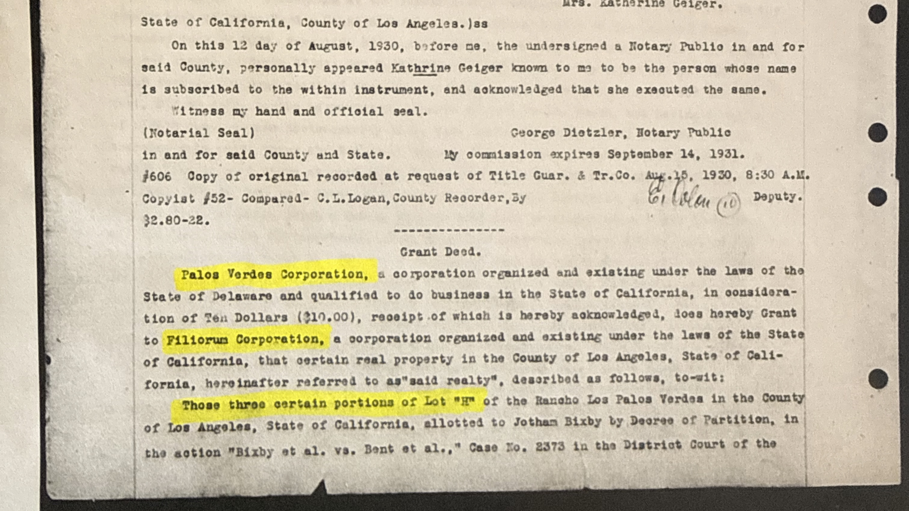
Case No. 2373, District Court, 17th Judicial District. Jotham Bixby receives Lot “H” — the legal parcel that will define every restriction and subdivision that follows. This is the origin point of the chain of title.
Context
Vanderlip, president of National City Bank of New York, buys the rancho as a real estate venture. He will spend the next two decades planning a planned community on the peninsula.
Context
Olmsted Jr. designs the community layout, road network, and open space system. Jacques Greber contributes the Villa Narcissa grounds at Portuguese Point. The Library of Congress holds 385 plans for the Palos Verdes project.
Context
PV Corp becomes the entity that will sign every founding declaration between 1929 and 1952. Kelvin C. Vanderlip (Frank Sr.’s son) serves as president. The corporation’s Delaware status and eventual dissolution are central to whether the restrictions can ever be released.
Declarations & Development
Record
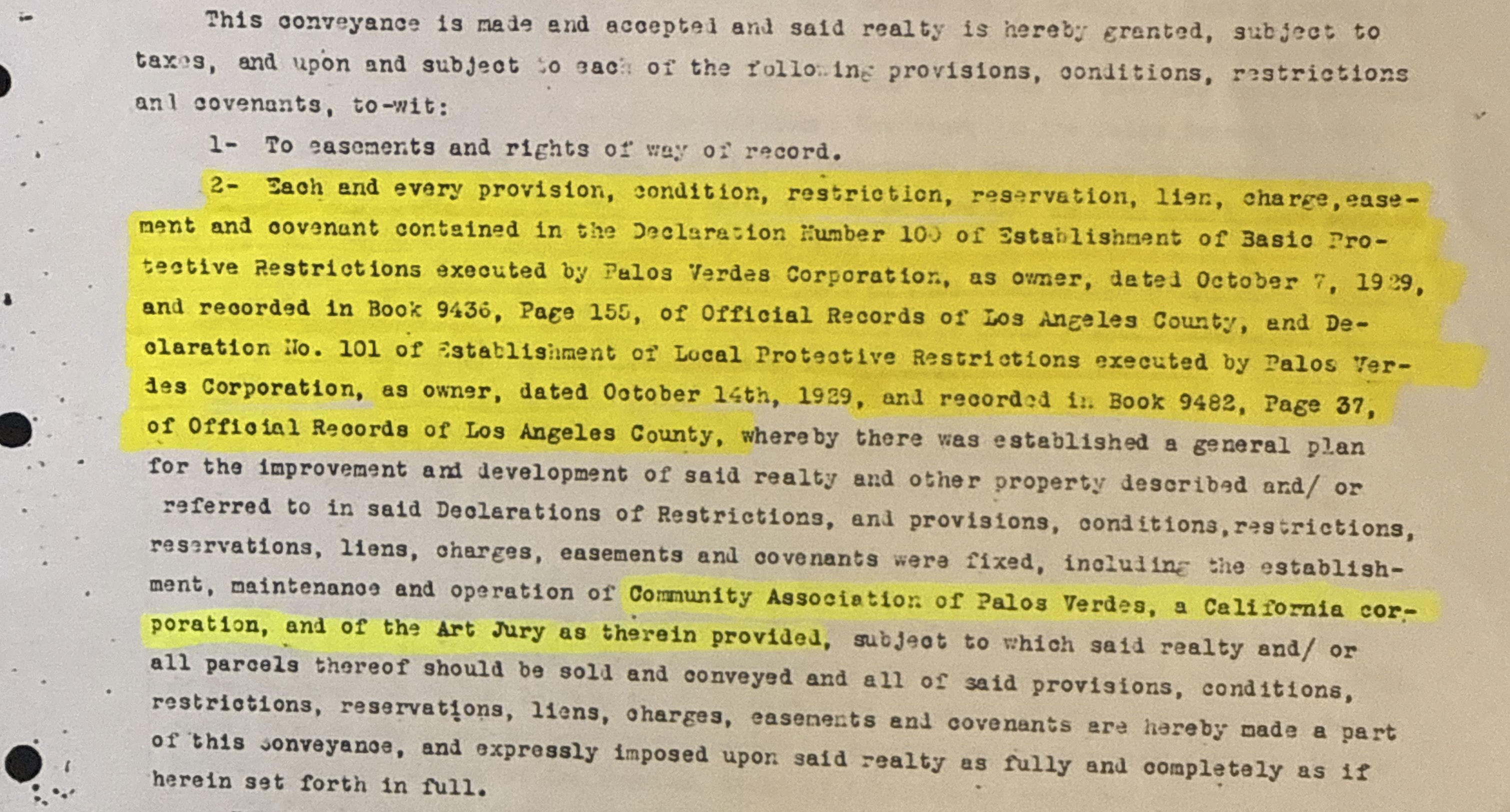
Book 9436, LA County Recorder. Establishes basic protective restrictions and an Art Jury (architectural review board) for the Portuguese Bend area. This is the PV Corporation’s first layer of covenant protection for the south coast.
Record
Book 9482, LA County Recorder. Applies local protective restrictions to seven named parcels in the Portuguese Bend area. These parcels include the land that will later become Shoreline Park — a connection not referenced when the city acquired those parcels in 2014.
Context
The Shore Club will become the focal point of the 1972 condos-vs-park debate. Its corporate archives document the community’s relationship to the shoreline from the beginning.
Record
Book 10226, LA County Recorder. Grant deed from PV Corp to Filiorum Corporation, a family holding entity. Page six of this deed explicitly incorporates the restrictions of Declarations 100 and 101, binding the coastal parcels to the same architectural controls.
Record
Book 29980, Page 159, LA County Recorder. Signed by Kelvin C. Vanderlip (President) and John H. Robertson (Asst. Secretary) for Palos Verdes Corporation.
Creates the community’s governing framework: single-family residential use, Architectural Review Committee, maintenance assessments, enforcement and reversion of title. Article VIII provides mechanism to annex Lot “H” land into WPBCA. Duration: until January 1, 1974, then auto-renews in 10-year periods.
Record
Book 30051, Pages 385–393, LA County Recorder. Signed by Kelvin C. Vanderlip and John H. Robertson.
Defines metes and bounds of all easements within and around Tract 14649. Establishes two ocean access easements to the Pacific. Reserves utility, road, and drainage rights. Adds the physical infrastructure layer to Declaration No. One.
Record
Book 30174, Page 59, LA County Recorder. Increases allowable size reduction from 10% to 20% for one-story dwellings, except Lots 1–15 which permit no reduction.
Record
Book 32160, Page 26, LA County Recorder. Signed by Kelvin C. Vanderlip and John H. Robertson.
Covers everything PV Corporation owned that was not already in a named tract — the negative space. Same single-family restrictions as Declaration No. One, same ARC requirements, same enforcement and reversion of title. Duration: until January 1, 1975, then auto-renews in 10-year periods. Currently in force through January 1, 2035.
APN 7573-006-024 (0 Clipper Road) is not in Tract 14649. It is not in any excepted tract. It was PV Corp land in 1950. It falls under this declaration.
Record
Book 34817, Page 254, LA County Recorder. Adds 20-foot setback from Sea Cove Drive, 40-foot setback from bluff edge, 4-foot height limit within bluff setback, and ARC approval for all fences on Lots 1–5.
Record
Book 40601, Page 303 (Lot 1 template), LA County Recorder. Each grant deed references Declaration No. One — the buyer accepts all restrictions. This pattern repeats 81 times, carrying the covenants forward to every lot in Tract 14649.
Context
Great Lakes Carbon Corporation acquires PV Corp as a subsidiary. The Vanderlip family exits the corporate structure but retains significant Portuguese Bend acreage. PV Corp’s restriction authority transfers with the stock sale.
Geology & Regulation
Context
Road construction on Crenshaw Boulevard cuts into the ancient slide plane, reactivating the Portuguese Bend Landslide Complex. The slide will eventually destroy over 100 homes and reshape the regulatory landscape of the entire south coast.
Context
Dick Karshner proposes a condominium development on Shore Club land. Karl Rodi leads the opposition. The membership votes to pursue a public park instead. This decision directly leads to the creation of Abalone Cove Shoreline Park and, indirectly, to the incorporation of Rancho Palos Verdes.
Context
The condo fight and broader development pressure drive incorporation. RPV becomes the regulatory authority for the south coast, including Abalone Cove and the Portuguese Bend area. The new city inherits responsibility for land use decisions on active landslide terrain.
Context
A separate landslide activates in the Abalone Cove area, distinct from the 1956 Portuguese Bend slide. Together, the two slides form the Portuguese Bend Landslide Complex — the largest active landslide in Los Angeles County.
Context
Establishes state authority over development within the coastal zone. The Abalone Cove area falls within this zone. Any new construction requires a Coastal Development Permit in addition to city approvals — a second regulatory layer independent of local government.
Context
RPV adopts the Coastal Specific Plan to comply with the Coastal Act. Subregion 4 covers the Abalone Cove area and sets density, setback, and environmental review requirements for all development in the coastal zone.
Record
Map Book 950, Pages 14–15, LA County Recorder. The Wong family subdivides a portion of Lot “H” into Tract 32977: four single-family residential lots with dedicated open space. This is the only density ever approved for this parcel through the proper subdivision process.
Record
Map Book 1063, Pages 91–92, LA County Recorder. The subdivision is reversed — the four lots and open space parcel are merged back into a single unsubdivided parcel. The land returns to its pre-1980 status as unsubdivided Lot “H” acreage.
Modern Era
Record
Document 20090802242, LA County Recorder. Certified by Lowell R. Wedemeyer (President) and Anthony DeClue (Asst. Secretary).
Restates Declaration No. One as required by Civil Code 1352.5. Lists all 81 APNs of Tract 14649. Incorporates the 1949 Modification. Does not include APN 7573-006-024 (0 Clipper Road) — that parcel is Lot “H,” governed by the separate Lot H Declaration. Does not modify or restate the Lot H Declaration, Declaration One-A, or the Declaration of Easements.
Context
The five parcels conveyed to RPV in the 2014 redevelopment dissolution are subdivisions of Declaration 101 Parcels 1 and 5. Five match points verified: same Lot H, same Case 2373, same Mean High Tide Line, same road right-of-way, same PV Corp → Filiorum deed chain. The conveyance documents do not mention Declarations 100 or 101.
Context
The most recent speculator to acquire this parcel. The purchase is financed by Hankey Capital. Within three years, the city will rezone the parcel from RS-4 (single-family, 4 units/acre) to RM-22 (multi-family, 22 units/acre).
Record
Ordinances 678U (April 16), 680U (June 4), and 681 (June 18). The city rezones the parcel from single-family residential (4 units/acre) to multi-family residential (22 units/acre) — a 5.5x density increase on an active landslide, in the coastal zone, on land subject to the Lot “H” Declaration.
Record
Filed August 7, 2024. Alleges conflict of interest in the rezoning vote.
Record
Verified Petition for Writ of Mandate filed September 11, 2024, challenging the rezoning. The city demurs; petitioners oppose.
Context
The state housing agency confirms that RPV does not need Site 16 (0 Clipper Road) in its housing element to meet Regional Housing Needs Assessment requirements. The city can remove the site and still comply with state law.
Context
Despite HCD confirmation that the site is not needed for RHNA compliance, the City Council votes to keep Site 16 in the housing element. The rezoning remains in effect.